A magnificent balcony route above the Roya and Bévéra valleys, the hilltop villages trail takes you through chestnut and conifer forests and olive groves.
takes you through chestnut and conifer forests and olive groves.
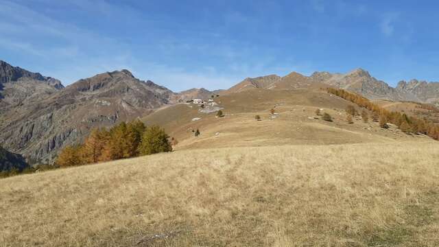
From Tende, at the top of the Roya valley, discover the Bévéra valley and the Mentonnais region. The route passes through hilltop villages and hamlets, between mountains and valleys. The trails, suitable for medium-level hikers, follow varied itineraries and lead to numerous viewpoints.
Along the way, you'll come across a heritage marked by history: Baroque churches, vestiges of the Maginot line, museums and railway stations dot the region. The area is also ideal for a wide range of outdoor activities, including hiking, white-water sports, mountain biking, climbing, paragliding and horse riding.
Stage 0: departure from the top of the geographical Col de Tende, passing through the hamlet of Casterino to reach the village of Tende: see below.
- 1st stage: Tende - St-Dalmas de Tende
Accommodation and public transport available
Tende - La Brigue
Duration: 2h15
Ascent: 350 m.
Descent: 340 m.
Opposite Rue de France (pedestrian zone), take Rue du Général Doyen (b.55) downhill, then head for the foot of the imposing railroad viaduct (b.53). Follow 100m of minor road to marker 62 and take the path through the undergrowth to the Aigle monument (b.61). The path climbs steeply up to marker 60, and a large ascending traverse leads to the Col de Boselia (1111m, b.285). Descend and cross the often dry valley (b.284). Head towards a young black pine plantation and descend a few tight switchbacks. Continue as far as the crossroads. Cross the Levenza stream on the road bridge (b.49). Reach the center of the village of La Brigue.
La Brigue - St-Dalmas-de-Tende.
Duration: 1h15
Ascent: 50 m.
Descent: 120 m.
From the town hall square, pass behind the chapel (b.44). From here, the path climbs slightly and then flattens out (b.43).
Cross the Armaneïra woods without difficulty as far as marker 42, a crossroads. Continue on to the place known as Ste Anne and continue along a railway shelter, then the "Pocassero" bars, crossing a ravine-like passage. Note that here you are above one of the famous underground spiral loops along the Nice-Cuneo railway line (b.41). Follow an access track to a house (b.41). Then head due north (right) to reach St Dalmas via a small, shady road (b.40). Return by train to La Brigue and Tende.
- 2nd stage: St-Dalmas-de-Tende - Fontan
Transport on request by reservation
St-Dalmas - Granile
Duration : 1h45
Ascent: 400 m
Descent: 0 m
Take the path at the Guardarena bridge (b.41a and 41b), on leaving St Dalmas at the junction of the Bieugne and Roya torrents. Reach Granile via the Fouigé and Ruga districts. The path, which is steep at first, crosses and skirts the little-used local road several times.
Granile - Upper Berghe
Duration: 30 min.
Ascent: 0 m.
Descent: 200 m.
The trail joins the path leading down to Paganin (b.219). Take the other path which passes the cemetery and church of Berghe Supérieur.
Upper Berghe - Lower Berghe - Fontan
Duration: 2 hrs 45 min.
Ascent: 200 m.
Descent: 500 m.
From Berghe Supérieur, pass marker 32, then follow the road to marker 211, and turn onto the path towards Berghe Inférieur to marker 212. Here you'll find a hikers' cottage called Berghon. Pass the hamlet and at marker 218, you start the descent to Fontan, passing marker 218a, then marker 218b, and finally the road to Fontan.
- 3rd stage: Fontan - Breil-sur-Roya
Accommodation and public transport available
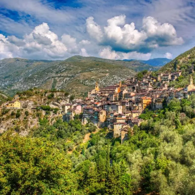
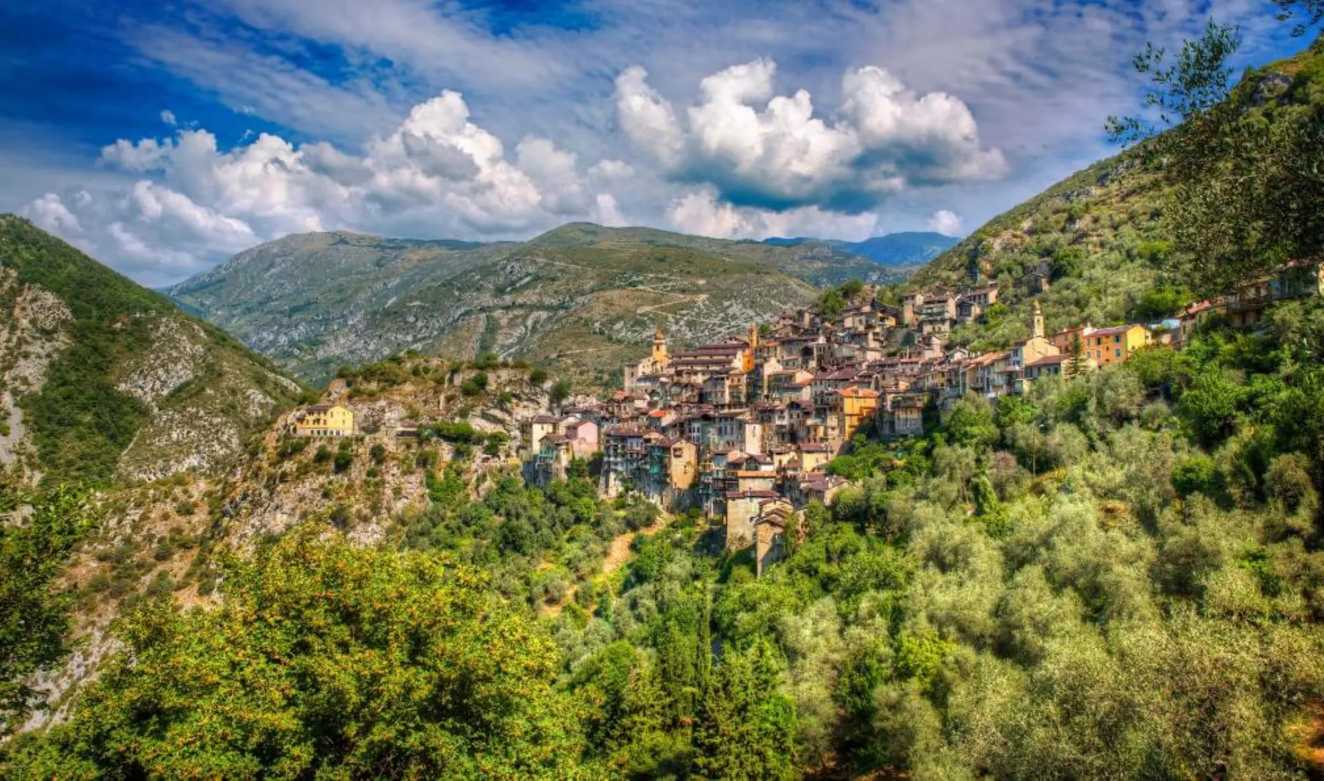
Fontan - Saorge
Duration: 2h15
Ascent: 436 m.
Descent: 346 m.
Head for the Fontan/Saorge station (b.431), following the road alongside the railroad (large wall on left), until you reach beacon 430, just opposite the station (on the left). Continue on to reach the pine forest overlooking Fontan, via a fairly long, unshaded climb. You then come to the path that rises above the roofs of Saorge (b.23). Reach the upper parking lot (b.21and b.22) and then the lower parking lot. This relatively long half-stage can be shortened by taking route départementale 38, which links Fontan to Saorge (distance 2.5km, 30 minutes slightly uphill). Be careful, however, as this little-traveled road takes you through a long (250 m), dimly-lit tunnel.
Saorge - Breil-sur-Roya
Duration: 3hrs 45mins
Ascent: 340 m.
Descent: 640 m.
Leave the village of Saorge (b.19), follow the path down the RN 204 for 100m (watch out for cars!) (b.17). You come to the Bain du Sémite (b.16), an inviting spot for a swim. Cross the Gorges de Saorge on a magnificent balcony path, then descend to a vast scree slope. Cross the scree. You come to a place called Chiendat (b.156), then to a cultivated property (b.154, b.155). Join the Caïné valley. You reach the Orneglia district, still inhabited (b.153), then the Zouayné valley (b.108). At marker 10, cross a landscaped pine forest (b.9), then cross the Roya by the road bridge. Cross the village of Breil sur Roya either along the central street, which is always shaded, or along the lakeside. Return by train to Saorge
- 4th stage: Breil-sur-Roya -Sospel
Accommodation and public transport available
Breil-sur-Roya - Piène Haute
Duration: 2h30
Ascent: 300 m.
Descent: 0 m.
Go through Breil sur Roya in the direction of Ventimiglia; as you leave the village, in a bend, a path starts off to the right (b.2). Follow the signs to Piène-Haute. Walk quietly to marker 118, then descend to the bottom of the valley, cross the stream and climb up the other side. At marker 439, you start the last short, fairly steep climb, in the shade of the pines, towards Piène-haute, which you can see perched on the ridge. The finish offers an exceptional view of both the sea and the surrounding mountains.
Piène-Haute - Sospel
Duration: 2h30
Ascent: 0 m.
Descent: 250 m.
Leave Piène Haute along the tarmac road towards Sospel (b.115), and 200m further on, take the path on the left towards the chapel of St Jerôme, from where you can see the sea. Once on the road, turn right towards Sospel. After passing an old lime kiln and a 17th-century siphon bridge on your right, take the GR 52 towards Sospel along the "sentier botanique". Return to Breil-sur-Roya by train.
- 5th stage: Sospel - Gorbio
Accommodation and public transport available
Distance: 25.6 km
Minimum altitude: 335 m
Maximum altitude: 1178 m
Cumulative ascent: 1362 m
Cumulative vertical drop: 1363 m
- Stage 6: Gorbio - Menton
Accommodation and public transport available
Distance: 16.6 km
Minimum altitude: 3 m
Maximum altitude: 653 m
Cumulative elevation gain: 371 m
Cumulative vertical drop: 746 m
Services
Pets welcome
Rates
Free access.
—
Openings
All year 2026 - Open everyday
ATTENTION: Ask the tourist office about weather conditions and possible landslides depending on the season.
Subject to favorable weather
Subject to snow conditions
Location
Spoken languages
Spoken languages
Environment
Environment
- Close to GR footpath
- Forest location
- Less than 10 minutes from a bus stop on foot
- Village centre
- Presence of livestock and guard dogs
- Village 2 km away
- Less than 10 min walk from a train station