10 ideas for walks in the Esterel region

A jewel of the Côte d’Azur takes you up high and reveals all its wonders. This volcanic massif, strongly contrasted by the three primary colours, offers breathtaking panoramas. Suitable for all levels of hiker, a multitude of trails are available all year round. Discover our selection of the 10 most beautiful hikes to do in l’Estérel.

Hiking in the Esterel :

Circuit de l’Aiguille

Level of difficulty: Easy. Time: 1h30.

Distance: 2.5 km. 160 m.

Starting point: Théoule-sur-Mer at the Esplanade du Général Charles de Gaulle car park.

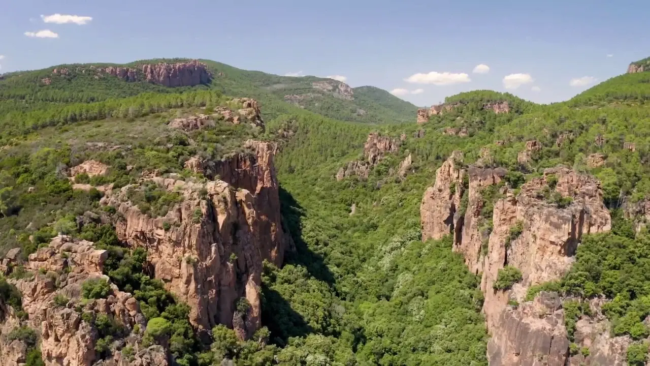
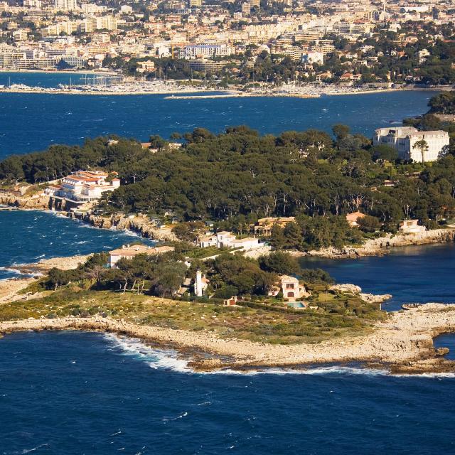
At the heart of unspoilt nature, the Pointe de l’Aiguille Departmental Nature Park has a breathtaking porphyry spectacle in store for you. Embark on the Aiguille circuit and get ready to be seized by a remarkable contrast of colours and landscapes.

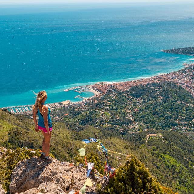
At the gateway to the Estérel, a forest path lined with Provençal vegetation will take you up high to contemplate the peaks of the Mercantour and the famous bay of the Côte d’Azur.

The massif’s volcanic past, dating back to the geological era, justifies the presence of red-garnet coloured cliffs. Formed by lava flows and erosion, the Pointe de l’Aiguille natural site is home to a picturesque pebble beach revealing a secret cove, the Grotte de Gardanne, where smugglers enjoyed hiding out to escape customs officials.

Consult the hiking itinerary

Le Rocher de Saint-Barthélemy

Level of difficulty: Easy. Time: 1h40.

Distance: 3.2 km. Elevation: 77 m.

Starting point: Saint-Raphaël at the Rocher de Saint-Barthélemy car park

A stone’s throw from Anthéor, the Rocher de Saint-Barthélemy walk is ideal for all the family.

Only flat and asphalted, children can have fun on bikes, scooters or rollerblades.

To reach the rocky promontory, simply follow the botanical trail, which allows the whole family to become untaught about the flora that surrounds them on this lovely walk.

The striking contrast of colours and the jagged effect of the landscape awaken the imagination of young and old alike. Only the immense expanse of Mediterranean blue and the panoramic views over the bays of Cannes, Mandelieu and Anthéor will remind you that you’re walking on the Côte d’Azur.

Consult the walking itinerary

Le Cap Dramont

Level of difficulty: Easy. Time: 2h00.

Distance: 3.8 km. Height gain: 151 m.

Starting point: Saint-Raphaël on the Camp Long beach.

Cap Dramont is an unmissable spot in the Estérel massif.

This unspoilt natural area offers a breathtaking view of Île d’Or, Agay Bay and Saint-Raphaël Bay.

A waymarked path, surveying the jagged rock face, allows the whole family to enjoy the red rocks at their own pace.

A detour via the Semaphore will give you a bird’s eye view of the Cap, then a short break at the Port de Poussaï, a picturesque fishing port, will be pleasant before completing the loop.

Consult the hiking itinerary

The Grand Duc circuit

Level of difficulty: Easy. Time: 2h30.

Distance: 6.1 km. 220 m.

Start point: Mandelieu-la-Napoule at the car park on Route Départementale (RD) 92 towards Tanneron.

On the edge of the Route d’Or, also known as the Route du Mimosa, the Grand Duc trail is a real breath of fresh air for the family.

With a breathtaking view of the Lérins Islands and the bay of Cannes-Mandelieu, the forest trail presents no difficulties.

When the Mimosas, the emblematic tree of the Tanneron massif, are in bloom, an olfactory and visual adventure awaits you in Europe’s largest Mimosa forest!

Note for families, the trail is not suitable for pushchairs, so bring a baby carrier for toddlers.

For walkers, a longer loop of 9.5 km is also possible (duration: 3h45).

Consult the walking itinerary

Le Rocher des Monges

Level of difficulty:Medium. Time: 2h30.
Distance: 5.9 km. 300 m.
Starting point: Théoule-sur-Mer marina.

To enjoy a beautiful view of the Préalpes d’Azur, the peaks of the Mercantour and the Mediterranean coast with its various ports, this hike in the Estérel is ideal. The striking mix of colours, from the green of the cork oaks and pines to the red of the rocks plunging into the azure blue of the Mediterranean, will undoubtedly take you on a journey through different worlds and moods. As you walk around the Rocher des Monges loop, you’ll see the famous statue of Notre Dame d’Afrique, inspired by Algerian religious art, rising up against the immensity of the Mediterranean Sea.

Hike itinerary

Le Rastel d’Agay

Level of difficulty:Medium. Time: 2h30.

Distance: 8.4 km. 360 m.

Starting point: Agay at the Togo car park.

Slightly removed from the coastline, the Rastel d’Agay hike nevertheless offers spectacular views from the heart of the Massif de l’Estérel to the Côte d’Azur coastline. Take in the view from the orientation table, which will show you the location of the Gratadis forest house, a unique heritage bequeathed to us by our ancestors. You can also admire the Pic de l’Ours and the Pic du Cap Roux from a 360° viewpoint. An ideal hike in the heart of l’Estérel, whatever the season!

Consult the hiking itinerary

Les Gorges du Blavet

Level of difficulty:Medium. Time: 3h00.

Distance: 6 km. 141 m.

Starting point: Bagnols en forêt at the Gorges du Blavet car park.

A new suggested itinerary that is sure to delight hiking enthusiasts!

Here, the Estérel will seduce you with its Gorges du Blavet as curious as it is spectacular. It’s a panorama of red rocks and lush green vegetation overlooking the river Blavet to contemplate from the observation table.

The Grotte du Muéron and remains of millstones dating from the 18th century are to be discovered throughout the hike. A shady path in the heart of the Estérel surrounded by wild orchids, cork oaks and chestnut trees, nevertheless good shoes are a must!

Consult the hiking itinerary

La Crête des Grues

Level of difficulty:Medium. Time: 4h00.

Distance: 11.6 km. Elevation: 540 m.

Starting point: Théoule-sur-Mer from the Vallon de l’Autel car park.

With this hike, get some height in the Estérel to discover two generous peaks in the massif: the Petites Grues (413 m) and the Grosses Grues (440 m).

As you climb the Crête, the Lérins islands decorate the landscape in the distance and guide our eyes towards the high peaks of the Ile de Beauté, often visible on a clear day.

A favourite territory for cork oak, maritime pine and maquis, the Var’s carpet of greenery stretches out before you at every stage of the hike.

A particular favourite for February: the start of this hike in the Estérel is surrounded by mimosa trees in bloom.

Consult the hiking itinerary

The Pic du Cap Roux tour

Level of difficulty: Difficult. Time: 4h30.

Distance: 5.1 km. 500 m.

Starting point: Saint-Raphaël at the Parking de la Sainte Baume.

Always higher! The Pic du Cap Roux is “The place to be” in l’Estérel.

Culminating at 453 metres above sea level, it’s the ideal spot for 360° views of the Côte d’Azur.

Enjoy exceptional panoramas towards the Col de Saint-Pilon and the Col du Cap Roux, then round off this visual spectacle with the Pic du Cap Roux, which allows you to overlook the bays from Saint-Tropez to Cannes.

In winter, the view is breathtaking over the snow-capped peaks of the Mercantour.

On the way back, a diversion to the Saint-Honorat cave is possible to discover the habitat of the hermits Saint-Honorat and Caprais, once in search of solitude.

Consult the hiking itinerary

La Dent de l’Ours, the Utzel cave and the Estérel ravines

Level of difficulty: Difficult. Time: 6h50.

Distance: 17.85km. Elevation: 602 m.

Start point: Théoule-sur-Mer at the Vallon de l’Autel car park.

For experienced hikers, this final hiking suggestion reveals a completely different face of the Estérel, known for its red rocks and breathtaking views. Here, the secret underside of the massif is revealed: its caves and ravines. Each stage will surprise you one by one with little wonders such as the Lac de l’Ecureuil located at the foot of the Ravin de l’Ecureuil where a little swimming is possible for the bravest.

A mix of underground, vertigo and panorama, this hike will offer you an amazing diversity of scenery. Make sure you have good hiking boots, as you will come across a great many stones along the way. Be very careful on the descents.

Consult the hiking itinerary

Flight over the Gorges du Blavet
Vol au dessus des Gorges du Blavet
You'll love it too!