The route extends mainly through the Sestrière woods which guarantees early snowfall favored by a northern exposure which gives it, from the beginning of December, a winter connotation inviting snowshoeing.
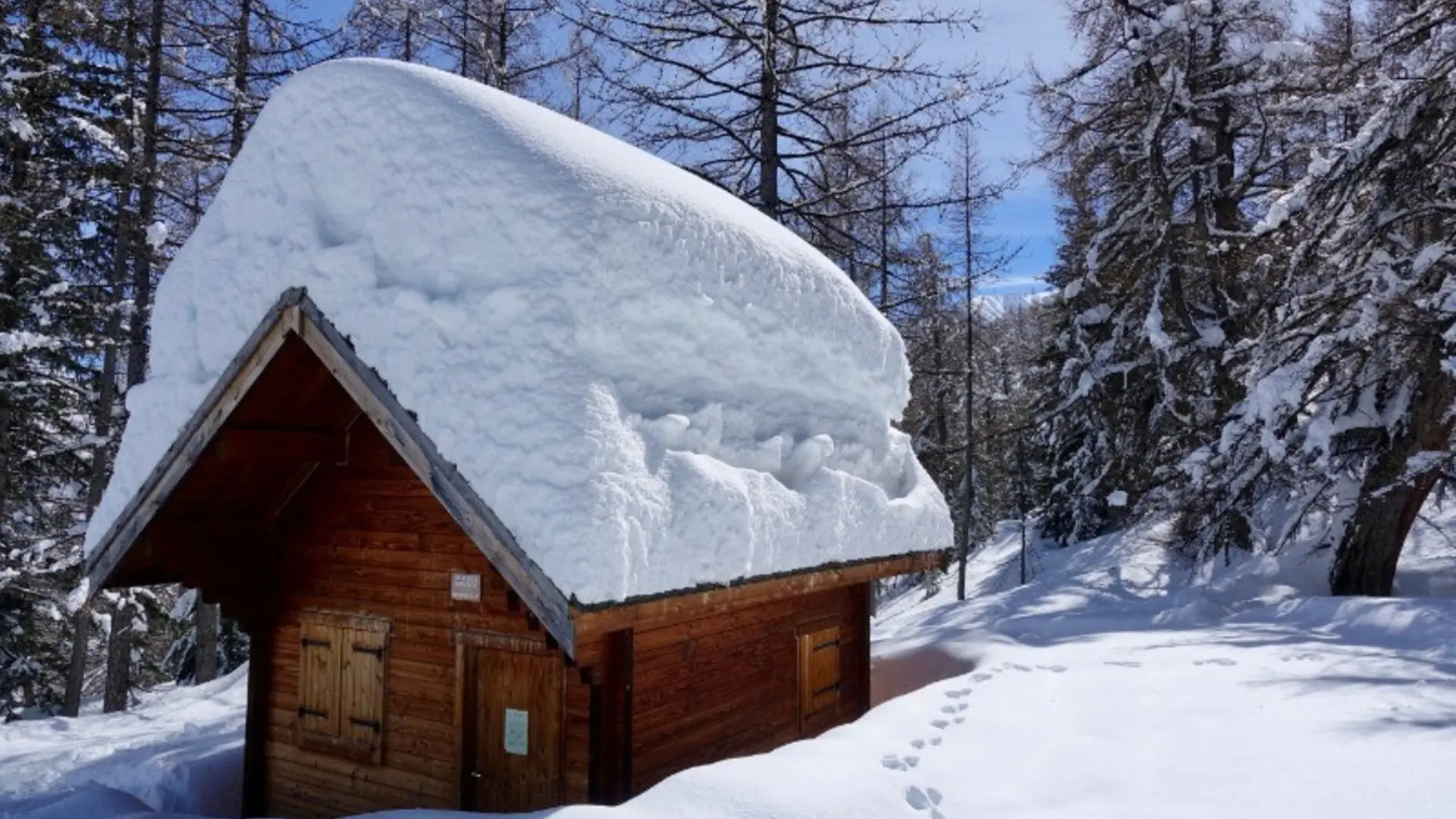
Along the forest tracks and snow paths, we will find the various traces and imprints left by the very varied alpine fauna that haunts the forest. Note: the presence at the high point of the circuit of the charming Gianto day shelter, specially set up by the municipality for the convenience of hikers. Please take the greatest care of it.
Taking place in the Nordic ski area, this route nevertheless crosses slopes exposed to avalanches. Consequently, it is important to find out before the opening of the Nordic area, depending on the conditions during the season and in the off-season, about the opening of the sector.
Easy hike
Elevation gain: +450 meters / - 450 meters
Distance: 7 kilometers round trip
Duration: 3 hours
Recommended period: December to March
Avalanche risk depending on conditions: Requiring
Cartography: TOP 25 n° 3639 OT
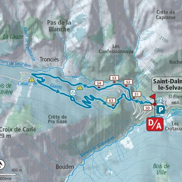
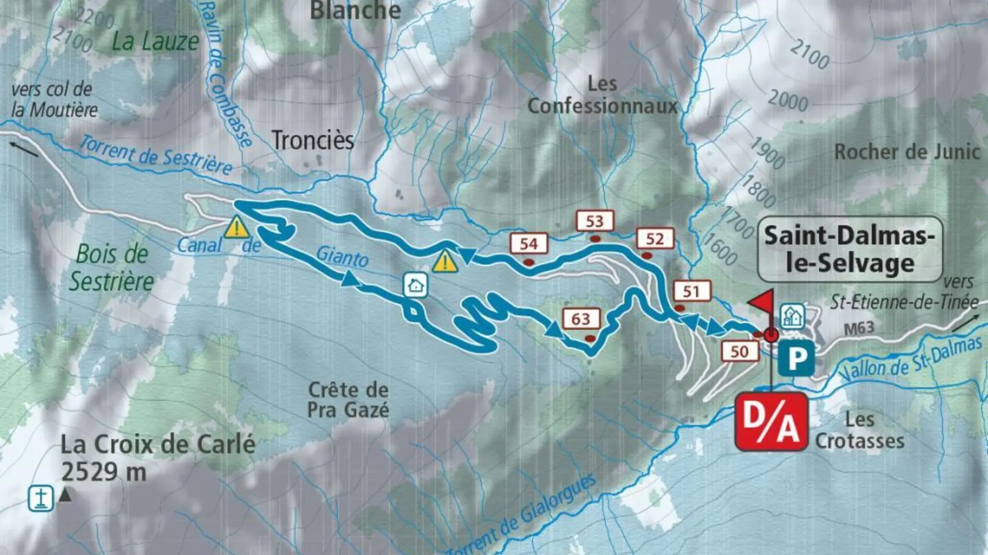
Itinerary :
From the village entrance car park, cross the stream on a small bridge (b.50) and go up the path which cuts the bends of the Sestrière road (b.51); follow this for around 500 meters before avoiding three bends along the way. In hard snow, there is a risk of slipping on this section with possible serious consequences.
It is therefore advisable, from marker 52, to take the track leading to marker 54 on the left, walking on the route of the road for approximately 1.5 kilometers before turning left to pick up the signposted route (marker “ snowshoe") which rises on a forest trail to the Gianto slope.
Follow this on the left (east) slightly upwards to the open day shelter of Gianto (1,920 m), the high point of the circuit. Then begin the descent by constantly following the track (6 bends) to the sunny plateau of Pra (1,750 m) and plunge into Saint-Dalmas-le-Selvage from marker 63 via a steep and winding path which joins the road and the route go to marker 51.
Taking place in the Nordic ski area, this route nevertheless crosses slopes exposed to avalanches. Consequently, it is important to find out before the opening of the Nordic area, depending on the conditions during the season and in the off-season, about the opening of the sector.
Easy hike
Elevation gain: +450 meters / - 450 meters
Distance: 7 kilometers round trip
Duration: 3 hours
Recommended period: December to March
Avalanche risk depending on conditions: Requiring
Cartography: TOP 25 n° 3639 OT
Itinerary :
From the village entrance car park, cross the stream on a small bridge (b.50) and go up the path which cuts the bends of the Sestrière road (b.51); follow this for around 500 meters before avoiding three bends along the way. In hard snow, there is a risk of slipping on this section with possible serious consequences.
It is therefore advisable, from marker 52, to take the track leading to marker 54 on the left, walking on the route of the road for approximately 1.5 kilometers before turning left to pick up the signposted route (marker “ snowshoe") which rises on a forest trail to the Gianto slope.
Follow this on the left (east) slightly upwards to the open day shelter of Gianto (1,920 m), the high point of the circuit. Then begin the descent by constantly following the track (6 bends) to the sunny plateau of Pra (1,750 m) and plunge into Saint-Dalmas-le-Selvage from marker 63 via a steep and winding path which joins the road and the route go to marker 51.
Rates
Free access.
—
Openings
From 1 January 2026 until 15 March 2026 - Open everyday
From 15 December 2026 until 15 March 2027 - Open everyday
Location
Spoken languages
Spoken languages
